

jayamini
-
Публикаций
20 -
Зарегистрирован
-
Посещение
Тип контента
Профили
Форумы
Календарь
Сообщения, опубликованные jayamini
-
-
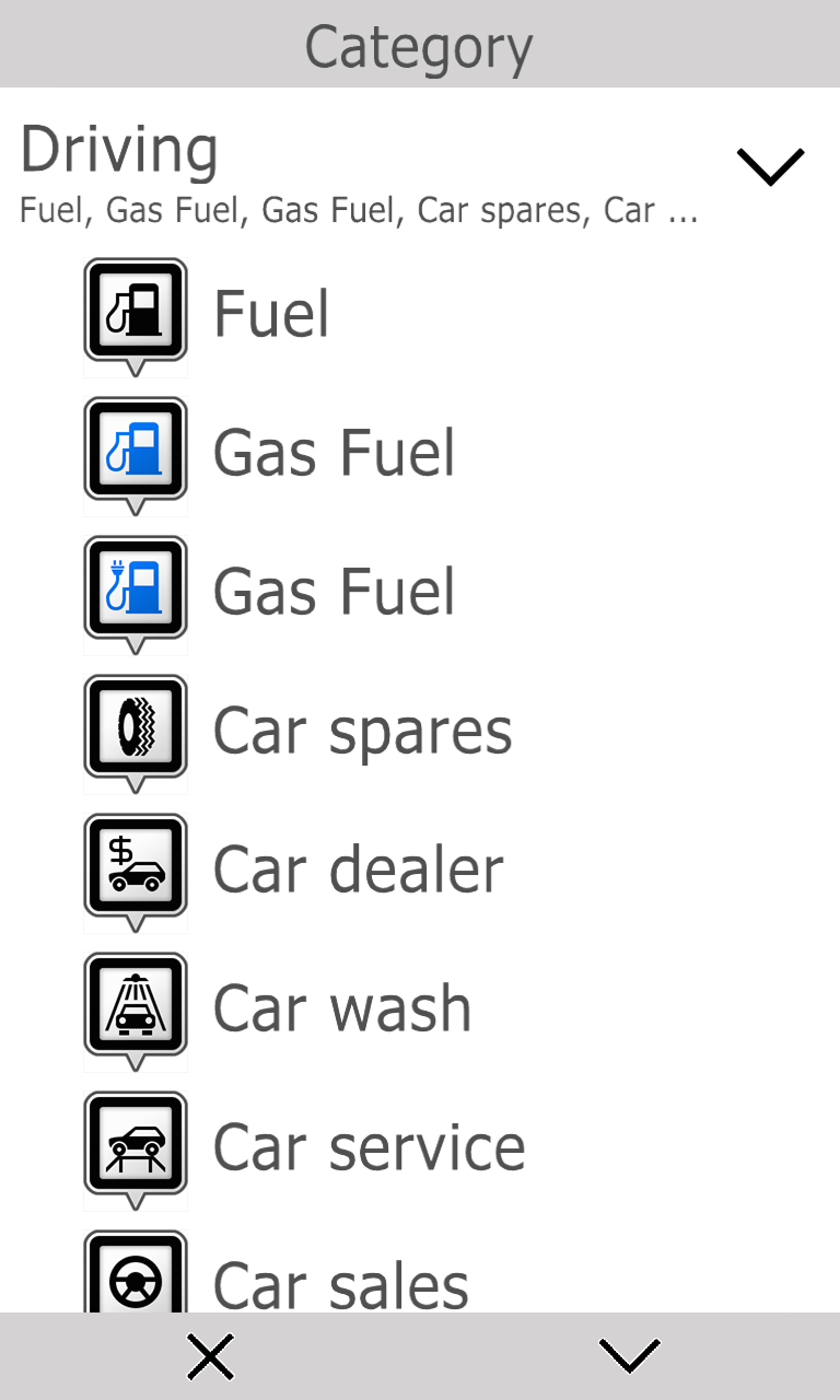
found that mp code for electric car charging points are 0x2FA1.
but if i use this value, in map it only shows name of the place no icon. i check inside Language pack. i can see i con for electric charging station with name FUELEL1.bmp. why it not showing on map?
when i try to add favorite and set type as electric charging station, it shows three types of fuel with name - fuel, gas fuel and gas fuel. 3rd one is without icon.
how to correct this. ?
device- galaxy note.
SW - Geonet 9.
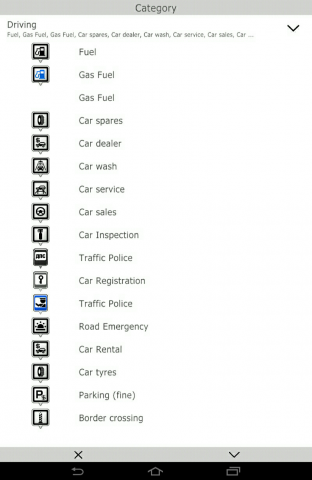
but in windows phone can see the icon

-
i have problem in address file creation. how to enable address search
-
I dont know. I do not create atlases and do not create the sdt file.
") Just I suggest you try.
Just I suggest you try.anyway thank you
-
To create the map, use the constructor 448. To create a std file, use a CGMapToolPublic of constructor 418.
Okay ill try that. that means 448 has bug ?
-
Check .mp. You have not Do to map other areas or objects with the same names?
Try to use the constructor 448.if i use 448 ,
(CGMapToolPublic.exe Type = CountryTownsCgnet InFolder =% WORK_PATH% InFile =% DCM%) std file is not generating properly it just only 1kb file
 that's why i use 418 . 418 create proper std file with 77kb.
is there any specific way to create std file ?
-
HI
when i creating cgnet file form mp i use below commands
GeoConstructor.exe -mp:%MP% -subrouter:5 -scamax:%MAP_MAX_SCALE% -codepage:1251 -version:%dv% -uniqueid:88888 -lang:EN
CGMapToolPublic.exe Type=CountryTownsCgnet InFolder=%WORK_PATH% InFile=%DCM%
7za a -tzip %DCM% %WORK_PATH%\%MAPID%.sdt
CGMapToolPublic.exe Type=CrtCGNet InFile=%DCM% OutFolder=%WORK_PATH%
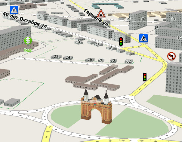
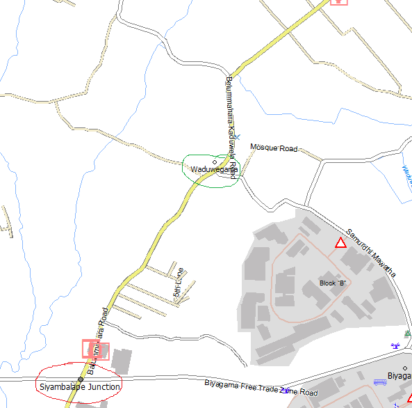
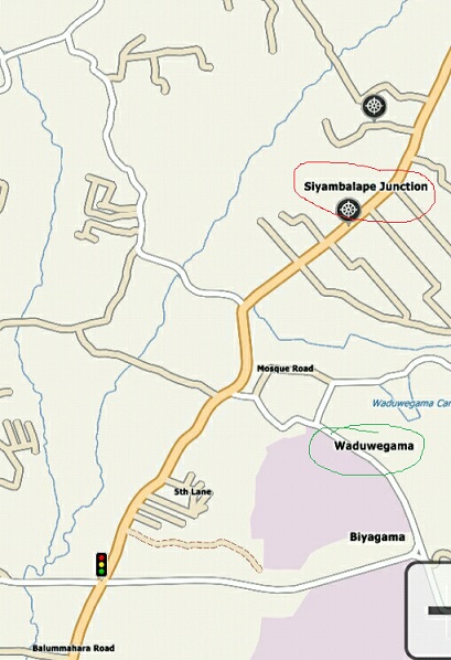
after creating cgnet file i can see towns and villages as displaced (they moved away from actual location). i check in mp file but town in correct location. even load in to geoconstructor town shows in correct place. but after conversion its moving away.
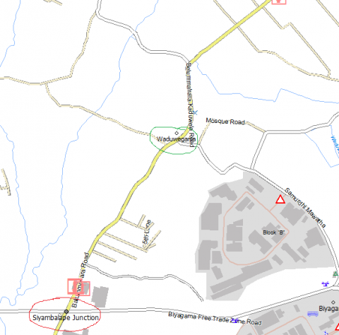
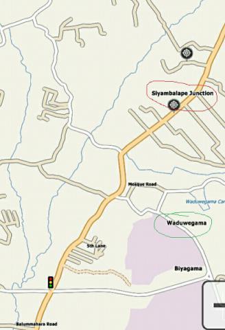
please see the position of 2 villages - "siyabalape" junction in Red and "waduwegama" in Green . first image shows in geoconstructor and second one shows in navigator.
i am using constructor 418 version
-
Hi ! File TEST.MapList.txt Should Contain A list of cards in the Format * . dcm , Which is Composed of the Atlas . It must be Located in the Same Folder as the overview map in the Format * . mp.
The example TEST. maplist . txt :
A. dcm
B.dcm
.....
Z.dcm
Thank you
-
Hi ,
When converting mp to cg
i can see this lines in log
* warning: cannot find file C:\Users\jayamini\Documents\mp\TEST.MapList.txt
* warning: address search: C:\Users\jayamini\Documents\mp\TEST.ist file created, but address file has empty names- what is the meaning of this ?
- How can i find or create this TEST.MapList.txt file
-
Hi
can anyone re upload the "mp2bkm" . existing link is not working.
-
Hi ,
While converting mp to DCM . below line found in log (Constructor_1.2.435_b )
* warning: 1 topological problem in the cell 260000BUILDS32334
* warning: 1 topological problem in the cell 260000BUILDS32332122do i need to correct them?
How ?
-
Иошкин кот! У нас уже два сингапурца!
ha ha !
-
 1
1
-
-
And I just ngliysky with the dictionary. Russian HELP never finished and the English even promise I will not.
oooops !
. tests is ok some how i will translate . but please put images and labels in english . else no way to understand -
GPSMapEdit 2.1:
thanx
how its looks nice -

How to create this kind of 3d roads , what are the properties need to set for this . specially in junctions
-
I spread a help. He added markers for regional centers and district centers. And image how to find duplicate addresses. All that added katran1961 left https://yadi.sk/d/7stOlFy9gZ7Me
I added some more explanation that appeared in the branch.
Added vidio instructions for working with scripts.
Hi soldat,
do you have English version of help. at lease videos. content can hardly translate but videos cannot(labels and messages appear in video )
. -
I do not understand !! Perhaps our colleague wants to know how to insert a picture in the card?
The first thing would be advised to straighten the corners is a polygon.
The second work since modelkoy. Not very nice to look at a map. The original building probably looks better than the picture.
And probably unsuccessfully selected object itself. This is a standard building. If you want to make a model, it should be visible on the map. Original. And it is very similar to the original.
It is desirable that the model is close to the road and immediately catches the eye. Since it carries with it not only a beautiful picture, but also a kind of landmark on the map.
And how to write our colleague Michael, the file name with the models must be the same as the name of the card.
You can make pictures or video. how the process of converting a file of *******. dc3
And yet see for yourself that you have turned on the card tampines.dc3
thank you
finally it works. i use this building just for test and learning. now going to create proper building with details. thank you every one -
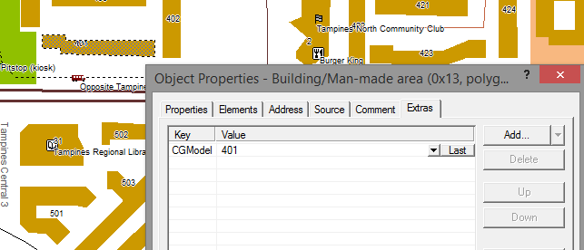
So can understand?
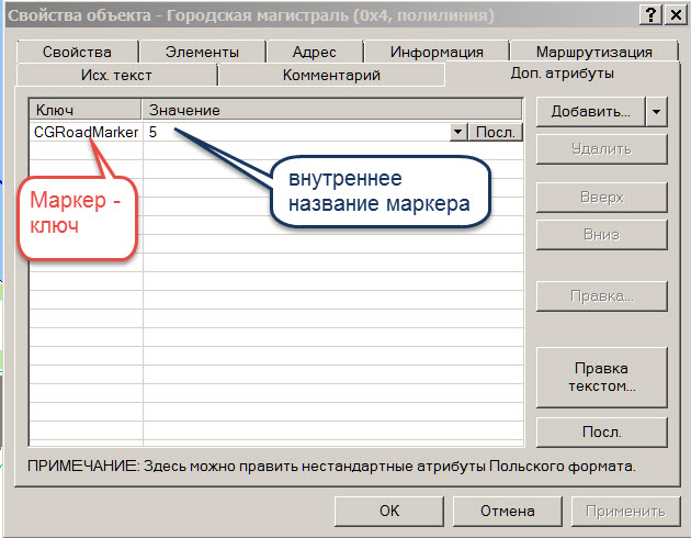
marker landfill CGModel = [name of the picture]
such a marker is placed polygons that have 3D picture
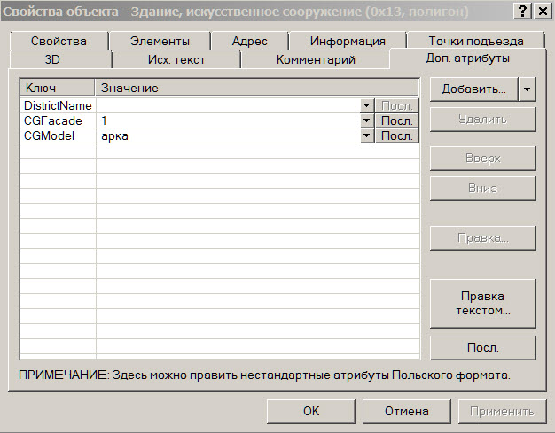
without this marker polygon on the map looks like this:
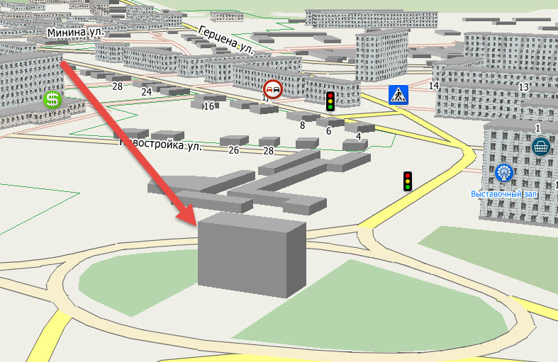
the creation of such models and further work with them in a map, click here: http://forum.micro-gis.com/viewtopic.php?f=25&t=44
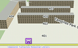
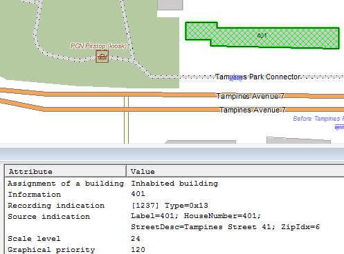
Hi,
I have create test map for my city (tampines - Singapore ) and i follow steps in this thread and http://forum.micro-gis.com/viewtopic.php?f=25&t=44&sid=533b0bcb0228dce9b5fa7af8eff8539c
i made one 3d model - biding and cgmap but model not show in map
. can you advice what is wrong ; WayID = 85560061
; building = yes
[POLYGON]
Type=0x13
Label=401
HouseNumber=401
StreetDesc=Tampines Street 41
ZipIdx=6
Data0=(1.35720,103.94536),(1.35707,103.94536),(1.35709,103.94459),(1.35713,103.94459),(1.35713,103.94444),(1.35724,103.94444),(1.35724,103.94463),(1.35720,103.94463)
CGModel=401
[END]i tried with 401 building in attached map (N1°21.4257' E103°56.7075')
-
Perezalil. I do not know why not swing.
Выставки пустую страницу
http://forum.probki.net/applications/core/interface/file/attachment.php?id=29684
-
Hospitals, institutions, and shopping I stamped storeys. Just prescribe dop.atributy
Non-residential building Type = 0x13Facade- # S8SIS8Krysha- # 808080Hospital Type = oxbFacade- # F5DEB3Krysha- # FFA07AResidential building Type = Ox6cFacade- # 92ADC3Kryshy- # BFB5B5Shops Type = ox8Facade- # FFFF01Krysha- # FFC001Institutions Type = 0xaFacade- # 66CDAAKryshi- # 008FFFBecause of this polish and remade. When a new polish out "peanuts" compared and am submitting my edits. Well, something like this. Though of course it is possible and in the constructor correct, but it is longer. In the HELP described as even video there.Как скачать PolishConverter_sold0309.rar ?
Учебный класс | подготовка карт для СитиГИД
в Инструменты для редактирования карт
Опубликовано · Изменено пользователем jayamini
thanx , icon corrected now, do you know the way to change the text , it just misleading "Gas Fuel" for charging station